Tax Unit Maps

The Tax Unit Maps are scanned from hand-inked maps produced and maintained by the County Clerk's office. Each map is bordered by township boundaries and therefore depicts a ~36 square mile area. The ~286 tax units graphically represent the aggregate property tax rates for the ~100 tax districts located in Sedgwick County.
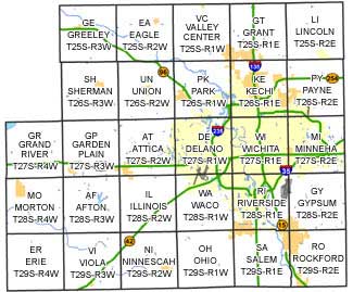
Townships

Afton Attica Delano Eagle Erie Garden Plain Grand River Grant Greeley Gypsum Illinois Kechi Lincoln Minneha Morton Ninnescah Ohio Park Payne Riverside Rockford Salem Sherman Union Valley Center Viola Waco Wichita Sedgwick County townships map
Township Township/Range
Afton Twp28S-Rng3W
Attica Twp27S-Rng2W
Delano Twp27S-Rng1W
Eagle Twp25S-Rng2W
Erie Twp29S-Rng4W
Garden Plain Twp27S-Rng3W
Grand River Twp27S-Rng4W
Grant Twp25S-Rng1E
Greeley Twp25S-Rng3W
Gypsum Twp28S-Rng2E
Illinois Twp28S-Rng2W
Kechi Twp26S-Rng1E
Lincoln Twp25S-Rng2E
Minneha Twp27S-Rng2E
Morton Twp28S-Rng4W
Ninnescah Twp29S-Rng2W
Ohio Twp29S-Rng1W
Park Twp26S-Rng1W
Payne Twp26S-Rng2E
Riverside Twp28S-Rng1E
Rockford Twp29S-Rng2E
Salem Twp29S-Rng1E
Sherman Twp26S-Rng3W
Union Twp26S-Rng2W
Valley Center Twp25S-Rng1W
Viola Twp29S-Rng3W
Waco Twp28S-Rng1W
Wichita Twp27S-Rng1E